Archeological sites in Grand Canyon National Park at risk
Study shows Glen Canyon Dam water releases directly affect site conditions
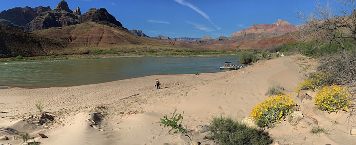
A research and monitoring area at a sandbar near an archaeological site along the Colorado River in Grand Canyon. (Photo/Joel Sankey, Grand Canyon Monitoring and Research Center, USGS.)
GRAND CANYON, Ariz. — Archaeological sites along the Colorado within Grand Canyon National Park and Marble Canyon show significant degradation from releases at Glen Canyon Dam according to a recently released report by the U.S. Geological Survey.
Over the last decade the condition of the majority of archaeological sites along the Colorado River within Grand Canyon National Park and Marble Canyon have deteriorated largely because of imbalances in the natural sediment cycle according to a new lidar monitoring report by the U.S. Geological Survey.
The completion of Glen Canyon Dam in 1963 fundamentally altered the characteristics of the Colorado River by slowing and stabilizing the flow of nearly 40 million people’s source of water.
However, reducing the speed of the Colorado means that Lake Powell has been “filling with the equivalent of 30,000 dump truck loads of sediment every single day—100 million tons of sediment annually,” according to the Glen Canyon Institute.
The USGS report presents the results of monitoring conducted at 30 archaeological sites within 23 monitoring locations from 2010 to 2020.
“We’re monitoring these sites that are situated on or in river flood deposits and sand dunes that were formed from Colorado River sediment that was deposited primarily prior to the construction of Glen Canyon Dam,” said Joel Sankey, research geologist for the U.S. Geological Survey and a co-author of the study. “(These) sites are especially prone to erosion and damage caused by rainstorms and then the runoff of rainwater on the landscape.”
Generally the oldest sites are deeply buried and date back as far as 9,000 years ago however there are even older sites within Grand Canyon National Park outside of the river corridor. However, sediment that was once deposited on sites or that was blown by the wind to replenish what has been eroded away is trapped behind 563 feet of concrete at Glen Canyon Dam.
“There’s concern with climate change, we’ll continue to see an increase in the number of intense rainstorms during the monsoon,” Sankey said. “That’s something climate change modelers have projected (and) we’ve seen it in the rainfall records from recent decades in the Grand Canyon region. But if sites are buried by a protective cover of sand they’re less susceptible to being damaged from rainfall runoff processes.”
While exact locations and specific features are protected from disclosure from the Freedom of Information Act, most of the sections in the study are tribal ancestral sites according to USGS social scientist and co-author Helen Fairley.
“We have sites that include masonry dwellings, storage structures, irrigation systems, agricultural fields, campsites, (rock art), roasting pits and some resource procurement areas or quarries,” Fairley said. “So a great variety and many of them seasonal.”
However, some of the sites in the study area are of recent settler history such as mining claims, tent cabins and “infrastructure associated with old ferry crossings like at Lees Ferry” according to Fairley.
“We’re monitoring topographic changes at the sites using lidar remote sensing techniques,” Sankey said. “To assess whether sites were eroding or if they’re being buried by sediment over time, and then under what circumstances that river sand can still reach and protect sites from erosion.”
While the primary factor for the protection of these sites is the extent to which sand is being replenished and keeping them buried by a protective layer to offset erosion; encroachment of riparian vegetation is also a barrier to the transport of river sand from sandbars to archaeological sites by wind.
“Before the dam was constructed the riparian zone was largely devoid of vegetation,” Fairley said. “On an annual basis it was typical to have a late spring flood … It’s become increasingly thicker over time because we don’t have floods that remove the vegetation. And (it) really becomes a barrier to the movement of sediment.”
Additionally the encroachment of riparian vegetation is aided by non-native plants such as tamarisk, which now comprises around a third of all woody riparian vegetation in the Grand Canyon currently according to Sankey. However, Fairley is quick to point out some native plants have become invasive because of the absence of flooding and a lot of vegetation in GCNP receives constant watering compared to periods of low-flow in the pre-dam era.
“Our results are certainly showing that sites are eroding and we’re seeing sites are transitioning to this more degraded condition,” Sankey said. ”But there are opportunities for using management to try to reverse or slow down erosion of sites.”
Mitigation Efforts
There are three main strategies for mitigating the sediment deficit for river deposition and sand dunes according to the USGS: high-flow experiments (HFEs), low-flow experiments and vegetation removal.
High and low-flow experiments vary the river’s flow out of Glen Canyon Dam to mimic in the case of HFEs springtime flooding. However another experimental opportunity is to expose more sand in the river channels by dropping water levels in the river according to Sankey.
“We’ve seen that periods for as short two to three days are sufficient for allowing sand that was previously inundated by water in the river channel to be moved by wind from the river channel to the site; if you drop those flows,” he said.
However, these experiments are difficult to conduct when managing the degrading health of the Colorado River because of drought, overuse and climate change.
It’s been four years since the last HFE was conducted during the fall and those “were predicted to be conducted frequently (~3 out of every 4 years)” according to the Bureau of Reclamation’s September announcement to not carry out a HFE. The Bureau clarified its decision to not conduct a HFE citing concerns of transporting invasive smallmouth bass into GCNP, impacts to hydropower production and “and risks associated with exacerbating low reservoir elevations.”
Finally the National Park Service has been carrying out annual experimental removal of invasive riparian vegetation from specific sandbars to reduce barriers to sand movement.
“Our monitoring and research results show that most archaeological sites that are situated in river derived sand or in river sediment,” Sankey said. “They have an elevated risk of erosion that threatens their long term preservation. Without management intervention sites will likely continue towards increased erosion, more degraded geomorphic condition and that translates to decreased long-term preservation potential.”
The majority of archaeological sites in the GCNP river corridor were created by ancestors of Native Americans who still live in this region. So the sites provide a physical testament of Indigenous occupancy of Grand Canyon and also complement the oral traditions according to Fairley.
“We as Americans have a lot of emphasis on our historical records that we maintain in libraries and archives and the tribes traditionally didn’t do that,” Fairley said. “But these archaeological sites are in a sense the books (of a library). They’re the record of human occupancy in GCNP and the history of the tribes. In that respect, it’s important they be maintained as long as possible.”
- Driver identified in fatal accident on Perkinsville Road Sept. 19
- Latest Tik Tok challenges causing problems for Williams Unified School District
- Search at Grand Canyon turns up remains of person missing since 2015
- Plane wreckage and human remains found in Grand Canyon National Park
- Pumpkin Patch Train departs Williams starting Oct. 5
- Update: Man missing in Grand Canyon National Park hike found alive
- Receding water levels at Lake Powell reveal missing car and driver
- Man sentenced for attack on camper at Perkinsville
- Column: Lumber prices expected to stay high through 2022
- Elk rut season in Grand Canyon: What you need to know
SUBMIT FEEDBACK
Click Below to: